Gogles Alm - Glanderspitze

Wandern am Venet

Gogles Alm - Glanderspitze

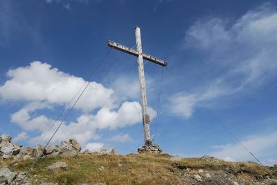
Fantastic hike from the Gogles Alm 2,017 m up to the Glanderspitze 2,505 m with a fantastic panoramic view.

From the Gogles Alm, first follow the E5 towards Wenns and then keep left, following the signs up to the Glanderspitze. The path winds its way in pleasant hairpin bends over grassy hills towards the summit. On the Glanderspitze 2,505 m you can enjoy a marvellous panoramic view of the breathtaking mountain world.

At a Glance

Difficulty level:medium difficulty
Elevation loss:486 m
Walking time / ascent:2 h

Information

Walking time / descent:1.33 h
Starting point:Fließ Dorf
Finishing point:Glanderspitze
Path surface:Asphalt, Forstweg, Steig
Tip from the author:This hike is also ideal as a bike&hike tour. The MTB route 795 leads from Fließ up to the Gogles Alm on good trails.

Fitness & technique

Fitness:4
Technical:3

Best season

Jun:Yes
Jul:Yes
Aug:Yes
Sep:Yes
Oct:Yes

City:Fließ

Altitude Profile

GPS Track

Download

Recommendable for Gogles Alm - Glanderspitze

In areas ofAlpine pasture

Gogles Alm  2 017m

Alpine pasture: Gogles Alm 2 017m

The Gogles Alm (2.017m) can be reached via an alpine and meadow trail from the mountain station of the Venet mountain railway in about 1 hour.
Online Booking / Request