Alpine and high alpine with incredible panorama you hike on these, more or less demanding, trails through the mountains.
Numerous alpine and high alpine hiking tours offer a majestic view over the Tyrolean mountains. The TirolWest vacation region is located on four renowned long-distance hiking routes in the Alpine area: Lechtaler Höhenweg, the yellow Via Alpina, Adlerweg, sections of the European long-distance hiking trail E5 and on four long-distance hiking routes in the valley area: Jakobsweg, Via Claudia Augusta, Starkenberger Panoramaweg and Burgenweg. Convince yourself of the fantastic possibilities.

Kaunergrat Nature Park House - Glanderspitze
Place: FließA beautiful hike from the Nature Park House to the Gogles Alm 2,017m, which can be reached in 2 hours and 15 minutes. From the Gogles Alm, a path leads in 2 hours to the Glanderspitze 2,512m with a magnificent panoramic view.
Read more
Naturparkhaus - Aifner Alm - Hoher Aifner
Place: Fließ | KaunerbergFrom the Nature Park House, it is a leisurely 2-hour hike to the Aifner Alm (1,980 m). The hike from the Aifner Alm to the Hoher Aifner (2,780 m) is more challenging and takes around 3 hours.
Read more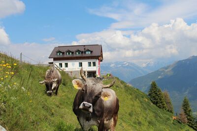
Circular route: Piller – fishpond – Gogles Alm – Glanderspitze (summit cross) – Pillerkreuz (summit cross) – Galflun Alm
Read more
Kälbergatter - Gachenblick
Place: FließBeautiful hike from the junction Kälbergatter in flow to Gachen view.
Read more
Urgen - Zöbele - Nedermaißwald
Place: Fließ Read more
Landeck - Thialkopf - Hochgallmigg
From Landeck via the Perfuchser ski hut up to the Thialkopf 2,398m. The trail leads down via Hochgallmigg back to Landeck.
Read more
Zams - Kronburg - Patscheid
Place: ZamsFrom Zams, the trail leads via Anreit and Rifenal to the Kronburg pilgrimage church. The short ascent to the Kronburg ruins offers a marvellous view of the surrounding mountains. The way back leads over the Zammer Patscheid.
Read more
Steinseehütte - Württembergerhaus
Place: ZamsThis three-day tour leads from Zams into the mysterious world of the barren Lechtal Alps. You immerse yourself in wonderful mountain solitude and spend the night in two cosy Alpine Club mountain huts. Back to Zams, you hike through the Zammer Loch, one of the most beautiful mountain valleys in Europe.
Read more
Landeck - Venetbahn Bergstation
Place: Landeck | ZamsStarting at the parish church in Landeck, the hiking trail number 3 leads you up to the Zammer Schihütte and Zammer Alm and from there up to the mountain station of the Venet cableway.
Read more
Zammer Alm/Skihütte Zams - Bettlersteig - Meranz Alm
Place: ZamsThis hike leads from the Zammer Alm/Skihütte Zams via the Bettlersteig to the Meranz Alm. You return to the Zammer Alm via the Lärchensteig and Tobi's adventure trail.
Read more
Fließ - Gogles Alm - Glanderspitze
Place: FließBeautiful hike from the car park above the turn-off towards Gogles Alm up to Gogles Alm 2,017m.
Read more
Hochgallmigg - Landecker Schihütte - Thialkopf
Place: FließBeautiful hike from Hochgallmigg to the Landecker ski hut and from there on to the Thialkopf.
Read more
Fließ - Hochgallmigg - Niedergallmigg - Fließ
Place: FließThis circular hike leads through both sides of the valley in the municipality of Fliess with wonderful views of the surrounding mountains.
Read more
Zams - Lahnbach - Krahberg
Place: ZamsAlong the Way of St. James up to Rifenal, then on to Lahnbach and over the ski hut to Krahberg.
Read more
Tobadill - Zirmegg - Thialkopf
Place: Tobadill | LandeckThe Flathalm, very popular with families hiking destination, invites you to linger and recharge your batteries for the last climb to Zirmegg. The fascinating spot on the Zirmegg and the unique view is worth the effort. With good visibility you can even see the Zugspitze!
Read more
Niedergallmigg sawmill - Hochgallmigg
Place: FließDer Weg führt von der Säge in Niedergallmigg über Zöbelen hinauf nach Hochgallmigg.
Read more
Grins - Grinner Schihütte - Strenger Schihütte
Beautiful hike from Grins via the Grinner Schihütte and Dawin to the Strenger Schihütte.
Read more
Grins - Augsburger Hut - Parseierspitze
Place: GrinsThe hut stands on a rocky outcrop from which you can enjoy a magnificent view. It is also the base of the Lechtaler Höhenweg and the starting point for the Parseierspitze, the highest peak in the Lechtal Alps.
Read more
Zams - Württemberger Haus
Place: ZamsThe path leads steeply up to the Burschlbödele, above the climbing area Burschlwand, and then leads along the long-distance trail E5 to the Jagerhütte. There, the path branches off and leads up to the Württemberger Haus.
Read more
Fließ - Bannholz - Spils - Jagerhütte
Beautiful hike from the centre of Fließ via Bannholz and Maranzgasse to the Jagerhütte.
Read more
Fließ - Schwaighof - Zammer Alm/Skihütte Zams
Place: Zams | FließHike from Fließ via Schatzen, Gamplesplatte and Larchegg to the middle station of the Venetbahn and on to the Zammer Alm/Skihütte Zams.
Read more
Fließ - Gogles Alm over Waldweiher
Place: FließBeautiful hike from the nature park community flow over the forest pond to Gogles Alm.
Read more
Zams - Zammer Alm/Skihütte Zams via Wiesensteig
Place: ZamsFrom Zams you walk on the paved road until after the hamlet of Anreit. ...
Read more

Fließ - Fließer Schihütte - Gogles Alm
Place: FließHike from Fliess via the Venet Süd valley station to the Fliesser ski hut. From there, a detour to the Gogles Alm is recommended for refreshments.
Read more
Landeck - Glanderspitze (Erzherzog-Eugen-Weg)
Place: Landeck | FließThe ascent over the so-called Archduke Eugen Weg lets you forget the effort of seeing the unforgettable mountain panorama, with striking peaks such as Wildspitze, Zugspitze, Ortler, Valluga, Riffler, Parseier and many more.
Read more
Fließ - Gogles Alm - Glanderspitze
Place: FließWonderful hike from the nature park community of Fliess via the forest pond and the Gogles Alm 2,017m to the Glanderspitze 2,505m.
Read more

Tobadill - Vorgiggl - Platils
Place: TobadillLeisurely hike from Tobadill to Wiesberg Castle, on to Platils and back to Tobadill.
Read more
Zams-Alfuzalm - Steinseehütte
Place: ZamsFrom the Alfuzalm leads a beautiful hiking trail to Steinseehütte.
Read more
Fließ - Bannholz - Spils - Jagerhütte
Beautiful hike from the centre of Fließ via Bannholz and Spils to the Jagerhütte.
Read more
Landeck-Perjen -Schrofenstein ruins
Place: Landeck | StanzPartial sections of the Way of St. James take you up partly steep paths to the lookout point at the Schrofenstein ruins.
Read more
Hochgallmigg - Thialkopf
Place: FließFrom Hochgallmigg to the Landecker Skihütte and up to the Thialkopf.
Read more
Zammer Alm/Skihütte Zams - Jagerhütte - Fließ
Leisurely hike from the Zammer Alm over to the Jagerhütte and on to Fließ.
Read more
Flathalm - Zirmegg - Perfuchser ski hut
Place: Landeck | TobadillA beautiful circular trail leads from the Flathalm to the Zirmegg, continuing via the Perfuchser ski hut and the Dreilalli trail back to the Flathalm.
Read more
Landeck - Flathalm - Zirmegg
Place: Landeck | TobadillThe route no. 19 represents a variant to No. 18, leads over the Waalweg (Drei-Lalli-Weg) to Falthalm.
Read more
Zams - Falterschein - Kronburg - Zams
Place: ZamsFrom the car park at the Venetbahn valley station, the circular trail leads via Anreit, Rifenal, Grist and Falterschein via Kronburg and the Zammer Patscheid back to the starting point.
Read more
Weg der Aussicht
Place: Zams | FließOn the popular "Weg der Aussicht", you can enjoy the circular path with its breathtaking view at the Venet mountain station.
Read more
Landeck - Zammer Alm/Skihütte Zams
Place: Landeck | ZamsFrom Landeck parish church, take hiking trail 3 up to the Skihütte Zams and Zammer Alm.
Read more
Stanz-Schrofenstein ruins
Place: StanzFrom Stanz the trail leads eastward slightly ascending and without much change of direction to the end of the forest road, from where you have a magnificent view to the ruin Schrofenstein. Back the round leads to the Kreuz Tragenden, then further down to the Dorfwirt and the starting point.
Read more
Zams - Zammer Alm/Skihütte Zams via Forstweg
Place: ZamsFrom Zams follow the Way of St. James up to the hamlet of Anreit. From there, a forest road leads up to the Zammer Alm/Skihütte Zams.
Read more

Kälbergatter - Wadlweiher - Piller Moor / 9
Place: FließBeautiful hike from the Kälbergatter junction via the forest pond to the Piller Moor and on to the Kaunergrat Nature Park House.
Read more
Fließ - Gogles Alm - Glanderspitze
Place: FließWonderful hike from the nature park community of Fliess via the forest pond and the Gogles Alm 2,017m to the Glanderspitze 2,505m.
Read more